By, Guy Cross, PhD, Geophysicist Terrascan Geophysics January 2000
1.0 INTRODUCTION
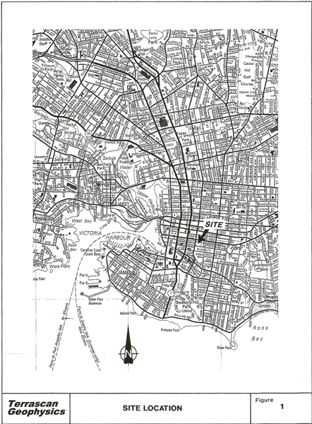
As requested, a non-invasive geophysical investigation has been conduted to detect and establish the location of unmarked graves within Victoria’s Pioneer Square Cemetery immediately adjacent to Christ Church Cathedral (Figure 1). In particular, a high-resolution electromagnetic conductivity survey was conducted June 1998. Soil electromagnetic conductivity measurements were acquired over an area of approximately 1500 square metres on the south side of the square, utilizing a combination of Geonics EM-31 and EM-38 conductivity meters. Electromagnetic reconnaissance was also conducted surrounding the Pritchard family monument near the northwest corner of the square to investigate the potential existence of a subsurface tomb. Over thirty potential grave anomalies have been identified within the primary survey area, including at least two major metal-lined vaults, one in association with an existing monument and another unmarked. In general, it is anticipated that identified anomalies are attributable to graves incorporating significant metallic content. Subsequent spatial filtering yields potential indication of numerous smaller more subtle features that may be indicative of relatively simple and perhaps earlier burials.
2.0 METHODS
2.1 Electromagnetic Conductivity Method
Basic principles of electromagnetic conductivity mapping are illustrated in Figure 2. An alternating current is fed through a wire transmitter coil, producing a time-varying magnetic field Bp that penetrates the ground and induces secondary electrical currents Je within subsurface materials in accordance with the principles of electromagnetic induction. These so-called eddy currents, in turn, give rise to a secondary magnetic field Bs that is sensed together with the primary field by the receiver coil. Over a uniform natural soil, induced current flow and, consequently, the strength of the secondary magnetic field (quadrature component) are approximately proportional to subsurface electrical conductivity (mS/m) which is controlled principally by porosity (soil compaction-consolidation), soil moisture content and mobile ion concentrations. Soil texture and mineralogy are also significant. Clays and silts are typically conductive compared with coarser grained sands and gravels.
In addition to apparent electrical conductivity electromagnetic instruments typically provide simultaneous measurement of the in-phase field component (ppt) which is directly related to effective magnetic permeability a particularly effective indicator of buried metal.
Selection of appropriate instrumentation involves a trade-off between spatial resolution and depth of investigation. In general, depth of investigation increases with coil separation and decreases with frequency. On the contrary, spatial resolution is improved by decreasing the inter-coil spacing and, consequently the volume of soil over which a given reading is averaged. Response characteristics for the EM-38 and EM-31 are compared in Figure 3. To ensure sufficient investigation depth the primary soil conductivity survey was conducted utilizing a Geonics EM-31 meter. Furthermore, both instruments can be operated in vertical or horizontal mode, meaning that transmitter and receiver coils are oriented such that their axes are vertical or horizontal relative to ground surface. As illustrated in Figure 3, depth sensitivity is significantly different for the two modes. For maximum depth of investigation and relative insensitivity to surface conductivity effects associated with variations in ground cover and surface moisture, measurements were acquired in vertical dipole mode, yielding a nominal range (70% cumulative response) of approximately 5.6 m, with peak sensitivity at 1.5 m.
Measured apparent conductivity is interpreted as a weighted average conductivity for a hemispherical subsurface soil volume having a radius equal to the nominal investigation range of approximately 5.6 m about the measurement point.
In the presence of localized subsurface inhomogeneities having effective dimensions comparable to or less than the nominal coil separation, measured conductivity depends upon coil configuration and target depth, as well as the electrical conductivity contrast between target and host soil. In particular, the electromagnetic conductivity signature of a grave depends upon the type of grave, material properties of the casket, if any, and the time elapsed since burial Typically, where excavated host soil is replaced as back-fill, a significant increase in effective porosity results in a proportional increase in moisture content and, consequently, electrical conductivity. The resulting vertical mode conductivity signature is almost invariably a negative-valued anomaly directly above the grave surrounded by a halo of high apparent conductivities. In corporation of metal within the burial would significantly enhance the response. Where a significant void space exists, a similar albeit potentially less pronounced signature would be expected.
EM-31 measurements were acquired at 0.5 m intervals along parallel north-south transects separated by 0.5 m. Apparent conductivity readings were made at waist level (approximately 1.0 m) with the instrument axis oriented parallel to transect. Data were automatically recorded via an Omnidata digital data logger and subsequently downloaded to a portable computer and processed in the field to ensure quality control.
Coincident EM-38 data were subsequently acquired over an approximately 625 square meter subsection of the survey area to investigate potential improvement in resolution at the expense of penetration. Again, readings were acquired in vertical dipole mode, yielding an effective range of approximately 1.5 m, with peak sensitivity at about 0.5 m. The sample interval was accordingly reduced to 0.25 m. Again data were digitally recorded in the field and subsequently downloaded to a portable field computer for processing and analysis. Reconnaissance surrounding the base of the Pritchard monument was conducted using the Geonics EM-38 in vertical mode along 0.5 m east-west transects. Investigation of the monuments base was carried out in random search mode.
3.0 FIELD INVESTIGATIONS AND FINDINGS
3.1 Primary Survey
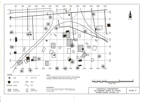
Apparent conductivity data acquired over the primary survey area are displayed in colour contour format in Figures 4-6. Note that depicted contour and colour levels are approximate and based on interpolation and extrapolation from actual point measurements. An extant plan of Pioneer Square, indicating existing monuments, trees and modern infrastructure is overlaid for reference. The corresponding geophysical interpretation is presented in Figure 7, identifying potential graves as either possible or probable, signifying relative interpretive confidence. Anomalies associated with lamp posts, metal-frame park benches and buried sprinkler lines are also observed. Two outstanding anomalies are observed at 50-55E, 15-20S and 42-46E, 10-15S and are certainly indicative of substantial buried metal, perhaps large lead-lined tombs. Due to substantial background soil conductivity variation within the survey area, additional smaller features are less evident in Figure 4 than via the corresponding in-phase response in Figure 5. It is anticipated that these lesser anomalies are also due, in large part, to buried metal, perhaps smaller lead lined vaults or metal coffins. Despite a relatively limited investigation range, EM-38 apparent conductivity data depicted in Figure 6 yields enhanced spatial resolution and more effective definition of subtle conductivity anomalies, potentially in association with common burials.
In an attempt to improve the effective spatial resolution of EM-31 data presented in Figures 4 and 5, background trends associated with large scale soil conductivity variation were removed via non-linear filtering to yield corresponding residual anomaly maps, accentuating localized anomalies as displayed in Figures 8 and 9. Although spatial filtering yields potential indication of numerous smaller more subtle features that could be indicative of relatively simple and perhaps earlier burials, these residual anomalies could as well be processing artifacts. In general, these features cannot be confidently attributed to potential graves.
3.2 Pritchard Monument
Results of EM-38 reconnaissance surrounding the Pritchard monument near the northwest corner of Pioneer Square are displayed in Figure 10. Again, depicted contour and colour levels are approximate and based on interpolation and extrapolation from actual point measurements. Superimposed upon a background trend toward higher apparent conductivity north of the monument, potentially significant anomalies are observed in immediate proximity to monument. In particular, anomalously high conductvities were recorded surrounding the southwest side of the monument base, while anomalously low readings were registered at the east end. Although the source of these irregular anomalous zones is difficult to interpret and may be due, in part, to structural reinforcement or bolting within the monument base, results may indicate the presence of a substantial structures, perhaps tombs, beneath the monument base. In particular, there is suggestion of two separate tombs, of significantly different construction.
4.0 SUMMARY AND RECOMMENDATIONS
Due to the indirect nature of non-invasive geophysical reconnaissance, interpretation of resulting data can never yield unequivocal findings. Geophysical anomalies tentatively attributed to the existence of unmarked graves within Pioneer Square Cemetery could, on the contrary, be due to unidentified modern cultural sources (i.e. subsurface infrastructure). Identification as potential graves is based on context and comparison with the signatures of marked graves. In addition, it is possible that there are existing graves that have not been detected and identified by the present survey. In connection with exploration and engineering applications we routinely recommend that some degree of direct ground truthing be undertaken to confirm and constrain the findings of geophysical investigations. However, recognizing that the nature of the present application precludes direct investigations, we suggest that additional information might be obtained via a ground penetrating radar (GPR) survey. The GPR method utilizes radio waves to image the subsurface in much the same way as commercial depth sounders use acoustic waves to yield a cross-sectional view of the ocean bottom. In combination with electromagnetic reconnaissance as reported here, GPR investigations have proved effective for detecting the more subtle expression of early historic and prehistoric burials.
We trust that the geophysical investigation reported here has adequately addressed your present requirements and will have a significant role in guiding future restoration of Pioneer Square Cemetery. Should you require additional information or clarification regarding our methodology or findings, please contact the undersigned at your convenience.